

PAGE CONTENTS
Objectives
The objective of the activity is to determine satellite ephemeris data (orbital parameters describing the trajectory of a satellite) for the purpose of improving the accuracy of geolocation systems and tracking of satellite orbits.
The following objectives are met:
-
To provide a product ready for the market able to satisfy the market’s demand for accurate satellite ephemeris data
-
To continuously determine satellite ephemeris data for the purpose of providing a tracking system for GEO, MEO and LEO satellites.
-
To provide very accurate satellite ephemeris data as input for geolocation systems for the purpose of improving their accuracy
-
To predict the trajectory of a satellite based on historical ephemeris data
In addition, this data can be used for:
-
Traditional satellite ranging activity (supporting flight dynamics operators to prepare satellite manoeuvres and calculate the state vector before/after the manoeuvre)
-
Collision and interference avoidance (e.g., coordination of co-located satellites)
-
Space situational awareness activity
-
Remote sensing applications.
Challenges
The key challenge of the project is to determine the orbital position with an accuracy better than traditional ranging systems. This requires to trigger the measurement on several ground stations at exactly the same time for calculating the Time Difference of Arrival (TDOA).
System Architecture
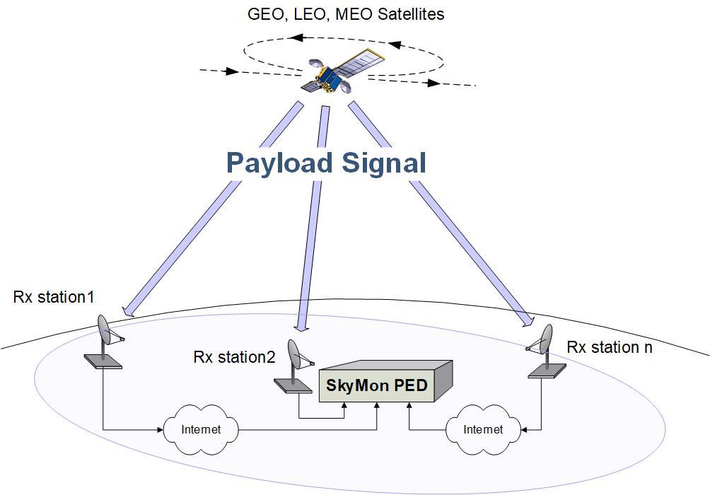
Main Elements
-
Rx Stations (minimum 3)
-
Small Size (1.2m)
-
Signal Sampling (USRP, B210)
-
1PPS Synchronization (GNSS Receiver)
-
Antenna Control (ACU)
-
Transfer of IQ Samples to Central Station (SkyMon PED, SkyMon ILS)
-
-
Central Station (SkyMon PED)
-
Controlling & Triggering Rx Stations
-
Computing TDOA/FDOA
-
Calculating Satellite State Vectors
-
Determining Orbital Elements
-
Plan
The project is done in three phases: First phase is to develop a Simulator for verifying the reachable accuracy of the system for different scenarios (# of Rx stations, orbital position, signal characteristic, etc.). The outcome of the Simulator defines the product specification and the basic design. In the second phase, the main algorithms are developed as well as the user frontend. In the third and last phase, the system accuracy and performance is verified.
Current Status
The project has been finalized. The product SkyMon PED is ready for sell. A demonstration system is setup in our development center in Prottes, Austria.
