-
StatusCompleted
-
Status date2014-12-09
- To design a prototype crisis management system for civil protection departments to be used in the case of major earthquake incidents.
- To demonstrate the benefits derived from the integration of satellite communication technologies and terrestrial wireless communication technologies with GIS technologies for the decision makers and the field operators that participate in the crisis management activities.
- To design an integrated system that will be able easily to provide similar crisis management services in cases of other natural or man-made disasters.
- To provide rapid and efficient data dissemination from decision makers to on-field operators and vice versa.
- To establish reliable and efficient collaborative working sessions between decision makers and on-field operators.
Critical issues affecting the development of the system have been identified to be the following:
- The integration of VSAT technology with the terrestrial wireless network,
- To achieve high satellite link data rate,
- To ensure availability of the satellite resources,
- To deploy an appropriate WiFi network,
- To ensure availability of near real time earth observation data and availability of archived earth observation data.
Some of the benefits of the ECM-GR system:
- Network expansion in the incident site through WiFi networking technology.
- Satellite transmission capabilities in case that the terrestrial network is corrupted.
- Immediate communication with the operational centre and transmition of critical data to it.
- Earth Observation capabilities and images from the incident site.
- Document chats, messages and responses in online.
- Capture digital and video images in the field.
- Promote communication and collaboration after the team has been notified.
- Delivery of alert messages.
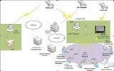
The overall architecture of the ECM-GR system consists of three main components: i) Operational Centre Terminal (OCT), ii) Incident Site Mobile Terminal (ISMT), and iii) Hand Held User Terminals (HUTs). The Operational Centre Terminal (OCT) is located at the command headquarters and is indented to provide the means for fast situation assessment and disaster management, as well as coordination of rescue teams, by providing the following:
- Two-way communication with the incident site.
- Internet Access.
- Acquisition of satellite imagery of the incident site.
- Viewing images and video related to the incident site.
- GIS software for viewing maps of the incident area and monitoring the position of the human resources and rescue team’s equipment.
- Software for reviewing damage assessment report forms.
The Incident Site Mobile Terminal (ISMT) is located at the site of seismic incident and is focused on the provision of communication services between the incident site and the OCT. The ISMT establishes communication with the OCT via a satellite link and transmits required data for the services provided from the OCT. In addition, the ISMT establishes TCP/IP communication with the rescue team members holding their HUTs via a WiFi network.
The Hand Held User Terminals (HUTs) are held by the rescue team members at the incident site. They enable the rescue team members to communicate with the ISMT over the WiFi network established by the ISMT, and transmit voice data, digital pictures and video, as well as GPS positioning data and identification data. As HUT can be consifered any pne of the following types of devices:
- PDAs
- Digital Camera, Video Recorder
- Laptop or Tablet PC
- Voice Communication terminals (IRIDIUM/GLOBALSTAR/INMARSAT mobile terminals)
The overall architecture of the system is shown in the following figure.
The Project was divided into two phases. In the first phase, the following activities took place:
- Definition of User Requirements and Scenarios
- Technology survey - trade offs
- Architecture Design
The above phases completed until the BDR. After the successful completion of BDR the second phase of the project was initiated. During the Second phase, the planned activites were:
- Prototype system Implementation
- Service validation
The ECM-GR project was stopped after MTR after mutual considerations about motivations and market requirements, after the long delays suffered. The completed tasks led to a prototype definition and partial integration of the ECM-GR system. The activities that were not performed according the initial planning were the complete integration and final trials. This fact affected the project in the mean of the final presentation of its uses and capabilities. A Final report describing the major results of the project and the lesson learnt was released.
Although the intended ECM-GR system was not integrated, this project has pushed the company to make available for the market the ECM-PLUS product. The ECM-PLUS is based on a subset of the ECM-GR project and has already been installed partially (components of ECM-GR) and operates successfully in Greek Prefectures. Moreover, based on ECM-GR, Aratos Technologies S.A. developed a new system, called ECM-Basic. It can be considered as a lightweight version of the ECM-GR system to provide vehicle positioning under extreme and difficult conditions such as heavy snowy mountains.


