-
StatusCompleted
-
Status date2019-11-28
In today’s space environment it is desirable to provide the means for autonomous navigation and control of spacecraft. This is caused by several factors which occur in combination as well as separately and can be summarized under reduction of operational efforts and mission critical constraints such as timing of manoeuvres.
Current Attitude and Orbit Determination Systems for geostationary satellites are typically based on Earth- and Sun-sensors, supplemented by gyros and ground stations for orbit determination. This trend, however, changed towards the increased use of star sensors as primary attitude sensors, which is a first step towards an APS based navigation sensor. The second step is to increase the capability to an integrated Earth-/Star Sensor for autonomous orbit determination.
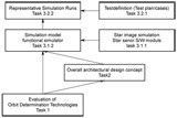
Basis for the new navigation sensor development is a collection of interesting ideas to design and implement the sensor. The work to be performed consists of 3 main tasks:
- Evaluation of Orbit Determination Technologies,
- Elaboration of an overall architectural design concept (two different concepts were evaluated):
- The sensors functional block diagram,
- Interfaces (data / power),
- Mass, volume, miniaturization,
- Expected orbit determination performance and robustness,
- Accommodation on spacecraft.
- Performance evaluation with simulator:
- Derivation of a simulation model (Simulator Software),
- Test setup and representative simulation runs.
With the invention of APS sensors, star trackers (STRs) have been improved greatly. In addition to STR enhancements these technologies allow the development of combined Earth- and star sensors (also called navigation sensors). The extremely low blooming effects allow the additional detection of moon, Earth or asteroids.
A navigation camera, which uses these new possibilities, is the consequential continuation of present navigation concepts. In difference to a star tracker in tracking mode the navigation camera may use a bigger part of the image for analysis.
The Earth measurement by airglow/nightglow (weak emission of light by the planetary atmosphere) is another design driving feature promising a better accuracy of the navigation sensor.
Study logic of “GEO orbit determination using an APS based Navigation Sensor”
The sensor’s design is mainly dependent on the detector, the optical system, the integration constraints on the satellite, the orbit and the objects observed. Main design aspects for this particular sensor are:
- Observation of the Earth using airglow/nightglow,
- The optics uses an Nb2O5 layer for the filter which is not yet qualified (can be qualified without additional development effort according to the manufacturer),
- Mechanical and optical restrictions and constraints (obstruction or reflection due to solar panels, bloom caused by propulsion system),
- Mechanical and baffle design,
- Characteristics arising from a large Field-of-View and its influence on the optics,
- Limitations due to low fill-factor,
- In-Orbit / Pre-Flight calibration.
The study part “Evaluation of Orbit Determination Technologies” gives an overview on different orbit determination methods and its advantages and disadvantages. The comparison of these methods to determine the one best suited for any given purpose is difficult by the number of parameters to be assessed. An extensive table gives an overview, highlighting most important parameters and giving a qualitative review. The parameters are grouped into technical and non-technical aspects.
The navigation sensor shows advantages concerning the following points:
- Low operational impact on unit level as well as on system level (during integration and in-flight operations),
- 3-axis attitude throughout the orbit,
- Compact unit,
- Good accuracy of orbit determination results, including sources for noise and bias,
- Better alignment between Earth and star sensor (concerning thermal and mechanical impacts) in response to the joint bracket is expected,
- Benefits concerning operational constraints such as availability, reliability and robustness of the investigated systems,
- Low estimated workload of qualified personal on ground / low recurring effort.
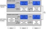
Besides the performed evaluation of orbit determination technologies the project covers two main parts: the navigation sensor design concept and the simulator software. The task of an APS based navigation sensor will be the autonomous determination of the orbit parameters of GEO satellites. The sensor uses star- and Earth measurements and determines:
- The attitude (star sensor part),
- The earth vector and the earth distance,
- The satellite position and the orbit parameters (data fusing and filtering).
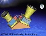
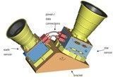
The design concept consists of two separate sensor heads, one Earth sensor and one star sensor, both mounted on a common bracket and connected by a power and a data interface. Thereby, the Earth sensor is only an extension to the star sensor without an own processor. The image processing for the Earth sensor including Earth acquisition, tracking, and fusion of Earth and star attitudes is done inside the star sensor within the free star sensor CPU time. With the Earth sensor 2 frames per second with a 12 Bit resolution will be acquired and a data stream of 25.2 Mbps arises. By the pre-processing (FPGA/ASIC) the data stream is reduced by about 2 orders of magnitude.
The SW simulator which has been developed in the frame of the study is based on a Java/C simulation environment, already used for GioveB and Galileo IOV. The APS sensor has been integrated as additional sensor equipment for orbit determination without an impact on the used generic GEO AOCS, i.e. the attitude quaternion and the Earth sensor measurement of the APS navigation sensor are not used for attitude control and the onboard orbit propagator integrated in the AOCS is operated independently from the APS navigation sensor. But the APS navigation sensor performance is influenced by the attitude error of the S/C platform.
The following milestone were successfully performed:
| Milestone | Date |
| Kick-off Meeting | 03.07.08 |
| Background Assumption Review | 03.12.08 |
| Preliminary Design Review | |
| Concept-1: same APS both for Earth and star measurements | 13.05.09 |
| Concept-2: independent Earth channel, airglow usage | 08.12.09 |
| Design Review (Simulator/Demonstrator Draft Proposal) | 28.01.11 |
| est Review Board | 24.05.11 |
| Final Review and Final Presentation | 18.07.11 |
The sensor concepts were discussed and the most promising one was selected to be further investigated. The simulator software is fully operational and validated. It can be used for benchmarking the demonstrator (in a next step). The studies final presentation was performed in summer 2011.
The study has been completed end of 2011.
Sophisticated navigation sensor simulator software has been produced and extensively tested, especially concerning the new navigation sensor data fusion and the operational aspects of the satellite.
Both the hardware as well as the basic software design was specified.
By now no sensor hardware has been produced. Hence, the implementation of the specified demonstrator setup and of the basic test equipment shall be performed with a subsequent project.


